Geospatial analysis often relies on raster data, n‑dimensional arrays where each cell holds a spatial measurement. Many raster operations, such as computing indices, statistical analysis, and classification, are naturally parallelizable and ideal for GPU acceleration.
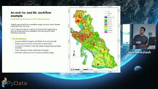
This talk demonstrates an end‑to‑end GPU‑accelerated semantic segmentation pipeline for classifying satellite imagery into multiple land cover types. Starting with cloud-hosted imagery, we will process data in chunks, compute features, train a machine learning model, and run large-scale predictions. This process is accelerated with the open-source RAPIDS ecosystem, including Xarray, cuML, and Dask, often requiring only minor changes to familiar data science workflows.
Attendees who work with raster data or other parallelizable, computationally intensive workflows will benefit most from this talk, which focuses on GPU acceleration techniques. While the talk draws from geospatial analysis, key geospatial concepts will be introduced for beginners. The methods demonstrated can be applied broadly across domains to accelerate large-scale data processing.